

| Copyright
Notice Home Page Site Map Tourist Information Places to Stay Local Events |
|
AROUND NORTH DEVON INNS & PUBS
|
| ABBOTSHAM |
| Local Beer/Real Ale |
| Thatched Inn |
| APPLEDORE |
|
Seagate
Hotel |
| BARNSTAPLE |
| Golden Lion Tap |
| Rolle Quay Inn |
| BIDEFORD |
| Kings
Arms White Hart Inn Blacksmith Arms Joiners Arms Crabby Dicks |
| BRADWORTHY |
| Bradworthy Inn |
| BRAUNTON |
| Williams Arms |
| BUCKLAND BREWER |
| Coach & Horses |
| CLOVELLY |
| New Inn |
| Red Lion |
| COMBE MARTIN |
| Pack of Cards |
| CROYDE BAY |
| Thatched
Barn Inn Manor House Inn Billy Buds |
| EXMOOR |
| Hunters'
Inn Royal Oak |
| The Rockford Inn |
| GEORGEHAM |
| Rock Inn |
| HORNS CROSS |
| Hoops
Inn Coach & Horses |
| HARTLAND |
| Anchor
Inn Wreckers Retreat The Hart Inn Kings Arms West Country Inn |
| HOLSWORTHY |
| Kings
Arms White Hart Inn |
| ILFRACOMBE |
| Royal Brittania |
| INSTOW |
| Quay
Inn The Wayfarer Inn The Boathouse |
| KILKHAMPTON |
| New Inn |
| LUNDY |
| Marisco Tavern |
| LYNMOUTH |
| Rising Sun |
| LYNTON |
| Beggars Roost |
| MILTON DAMEREL |
| Woodford Bridge |
| MONKLEIGH |
| Bell Inn |
| MORTEHOE |
| Ship
Aground Chichester Arms |
| MORWENSTOW |
| Bush Inn |
| NEWTON TRACY |
| Hunters Inn |
| PARACOMBE |
| Hunters Inn |
| SHEEPWASH |
| Half Moon Inn |
| SHEBBEAR |
| Devil's Stone Inn |
| SOUTH MOLTON |
| Stags Head Filleigh |
| SWIMBRIDGE |
| Jack Russell |
| TIVERTON |
| TORRINGTON |
|
Puffing
Billy |
| WEARE GIFFORD |
| Cyder Press |
| WEST DOWN |
| The Crown Inn |
| WESTLEIGH |
| The Westleigh Inn |
| WESTWARD HO! |
| Nelson Inn |
| Fairway Buoy |
| Pig on the Hill |
| Pier House |
| Waterfront Inn |
| WOOLACOMBE |
| Mill Inn, Ossaborough |
| WOOLSERY |
| Manor
Inn Farmers Arms |
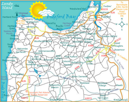
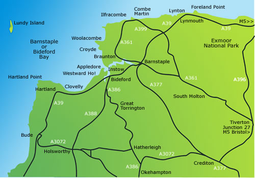
We have included a general North Devon Area Illustrated map which shows how Bideford is located in relation to the other major towns in the area such as Barnstaple, Braunton, Croyde, Woolacombe, Combe Martin, Lynton, Lynmouth, South Molton, Tiverton, Bude, Holsworthy and Great Torrington. On the more detailed map below you can use the links to view area and village picture tours, just click on the titles Abbotsham, Appledore, Bideford, Buckland Brewer, Bucks Mills, Clovelly, Ford & Fairy Cross, Hartland, Horns Cross, Instow, Parkham, Woolsery (Woolfardisworthy), Westward Ho!or click on the green arrows at the bottom of each page for North Devon Focus "Coast & Country Picture Tour". For more information, links to feature pages and online shopping please visit the North Devon Focus Home Page. Head over to Bideford, exit the M5 at Junction 27 and follow the signs for Barnstaple/Bideford on the A361 North Devon Link Road. The nearest railway station is at Barnstaple. The Tarka Line, one of the Great Scenic railways of Devon and Cornwall, runs for 39 miles between Exeter and Barnstaple, following the gentle river valleys of the Yeo and Taw. From Eggesford to Barnstaple the line forms part of the Tarka Trail, a 180 mile long distance route tracing the journeys of 'Tarka the Otter' in Henry Williamson's classic novel.
We have also included local Inns & Pubs around the area, the old buildings still stand, many still exist, though the names may have changed, sadly over the years some have permanently closed. We regularly update but we will leave the names of those *Gone but not forgotten* for historical value.AFFILIATE CONTENT The links to general information or products listed on this page are for your convenience. NB If you purchase through any affiliate link it may (or most probably not) result in a small commission. The merchant only knows you have visited this site if your Cookies are enabled.
BE PREPARED If you are planning your route for leisure or business use the following links to buy maps and guides online. Explore Devon with detailed Ordnance Survey maps and guides, perfect for walkers and adventurers seeking the beauty of the South West coast and countryside Ordnance Survey Website> https://tidd.ly/4fZAW7q
OS MAPS APP Premium annual subscription - https://tidd.ly/3WXJlja
Map of Clovelly & Hartland - Explorer 126 - https://tidd.ly/3X43wMk
Map of Bideford, Ilfracombe & Barnstaple - OS Explorer Map 139 (Woolacombe & Lundy) - https://tidd.ly/3T7tRIa
Barnstaple & Ilfracombe - Paper maps | Landranger 180 - https://tidd.ly/3XkQrQ2
Bude & Clovelly - Landranger 190 - https://tidd.ly/3yN7gtL
Map of South Molton & Chulmleigh - OS Explorer Map 127 (Kings Nympton, Chittlehampton & Dolton) - https://tidd.ly/3XcKDHk
Map of Exmoor National Park - OS Explorer Map OL9 (Barnstaple, Lynton, Minehead & Dulverton) - https://tidd.ly/3MrVg3K
| Click here for North Devon Focus Google Map & Tourist Information |
| Click here for the latest Highways Agency Traffic Infomation |
| READ ALL ABOUT IT: If you live in the area or planning a holiday and are interested in all aspects of the coast and countryside please use the links provided for books on the Bideford, North Devon and Exmoor Area or popular reference books on wild birds, butterflies, insects, flora & fauna and how to make the most of the Great Outdoors!. |
|
As an Amazon Associate I
earn from qualifying purchases
|
|
Turning
of the Tide (Kindle Edition) - The
Song of the Skylark (kindle Edition) - The
Postman Poet (Kindle Edition - All
Around the Year (Kindle Edition)
|
|
Hartland Quay The Story of a Vanished
Port
|
|
The Illustrated History of Appledore
by David Carter - https://amzn.to/2OXrNRW
|
|
A two hundred year history of Appledore
shipyards - https://amzn.to/31Zde5y
|
|
Bideford, Westward Ho! & Appledore
Railway (Oakwood Library of Railway History) - https://amzn.to/2SKoCON
|
|
The Valley of Rocks, Lynton (North
Devon Thematic Trails)
|
|
Geology at Hartland Quay - https://amzn.to/3X5qByb
|
|
Westward Ho! Against the Sea (North
Devon Thematic Trails)
|
|
North
Devon's Lost Railways
|
|
Pathfinder North Devon: Walks (Pathfinder
Guides)
|
|
Pub Walks in Exmoor and North Devon
(Pub Walks)
|
|
Exploring Green Lanes in North
and North-West Devon: And the Stories They Tell
|
|
 |
|
*An area of outstanding
natural beauty?
*Open fields, wooded
valleys and moorland?
*Country lanes leading
to picturesque villages and hamlets?
*Seafaring traditions,
quaint fishing villages and harbours?
*Rural communities
with traditional market towns & seaside resorts?
*Rolling rivers and
babbling brooks?
*Vibrant sunrises and
sunsets?
*Challenging walks,
coastal paths and miles of golden sand?
*Inspiration for artists,
poets and writers?
*Land of myths, local
folklore and legends?
*Dramatic cliffs, seascapes
and unique rocky shorelines?
|
|
Welcome
to North Devon
|
|
Use the Green
Arrows at the bottom of each page for the North Devon Focus Picture
Tour or use the area links on the Focus Home
Page
|
|
|